
|
TechnoOcean Academy: Coastal Geography of the World
| Logically, we should start with the top of the world, the Arctic, and work our way down methodically to the bottom of the world, Antarctica.
However, because our TechnoWrecks section is currently focusing on the east coast of the United States, we will begin our Coastal Geography there as well, beginning with Maine.
By the end of this course, you will know every inch of the coastlines of the world and the waters that surround them. |
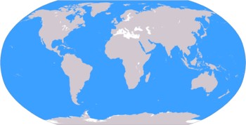
Can you identify every country and ocean on this projection? |
Maine: 1) February 12-18, 2007
Do you have an atlas of the US? Of the world? If not, get them! |
General facts
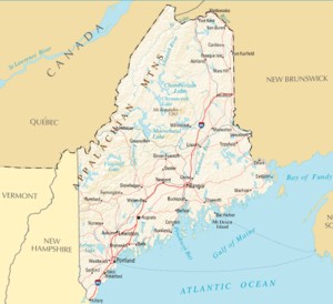
Maine is bordered to the north and northeast by New Brunswick, Canada, and to the northwest by Quebec, Canada; to the south and east by the Atlantic Ocean, and to the west by New Hampshire. Maine is the only state to be bordered by only one other state.
In other matters of geographical interest, Maine is the northernmost state in the New England region of the United States (comprised of Connecticut, Maine, Massachusetts, New Hampshire, Rhode Island, and Vermont), and is the largest of all the New England states -- accountng for nearly half of New England's land area. |
Unique Coastal Points
Machias Seal Island off Maine's easternmost point is claimed by both the U.S. and Canada, and is one of five North American land areas whose sovereignty is still in dispute. Also in this easternmost area is the Old Sow, the largest tidal whirlpool in the Western Hemisphere.
Maine is a sparsely populated state - most of the inhabitants live along the coast, for the interior - 90% of the state - is forested. There are thousands of islands lying off the coast of the state, and 62 lighthouses once blazed away in the night sky.
Our discussion of the geography of Maine's coastal waters will begin with a discussion of the coast itself - not only its geography but any man-made items of marine interst. We'll discuss the waters of Maine in Part 2 of this section, next week.
| Coastal Regions
1) Southern Maine
2) Midcoast
3) Down East |
In this section, we'll cover the first of Maine's three coastal regions, Southern Maine. Next week, the waters off Southern Maine. In the subsequent week, Midcoast, and two weeks after that, Down East.
Maine's coastline is a jagged one, full of bays and inlets. If you straightened out all the "twists and kinks" it would be 3,500 miles in length. Of these 3,500 miles of coastline, only about 35 miles are beachfront -- and much of these are located in Southern Maine. |
Have a detailed map of Maine to hand and consult it as you read through this section.
Southern Maine
|
Southern Maine, for our purposes can be described as stretching from the city of Kittery in the southwest corner, up to the city of Brunswick, in the northeast corner, just below the Midcoast.
Kittery is situated just across the I-95 bridge from Portsmouth, New Hampshire. The Portsmouth Naval Shipyard is located in Kittery, on Seavey Island within the Piscataqua River. However, New Hampshire claims that this island, and hence, the shipyard, actually belongs to New Hampshire. |
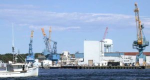
Portsmouth Naval Shipyard as viewed from the New Hampshire side of the Piscataqua River |
Assignment:
Read about the Portsmouth Naval Shipyard (Wikipedia article) [The official website is down for maintenance]. Also read the external sites for Fort McClary and Fort Foster below. |
On the Maine side of Portsmouth Harbour are a pair of historic forts overlooking the Piscataqua River: Fort McClary on the mainland, and Fort Foster, on nearby Garrish Island. We'll deal with the Piscataqua River next week.
Continuing northeast up the coast, you pass through York: York Village, York Harbor and York Beach. Cape Neddick Light, also known as Nubble Light is located at the north end of Long Beach, in the village of York Beach.
Continue northward through Ogunquit. North of this city, just past the town of Wells, is the Wells National Estuarine Research Reserve. This reserve possesses thousands of acres of coastal marshland as well as forested uplands.
Further along the coast, and covering 50 miles of coastline, is The Rachel Carson National Wildlife Refuge.
Next you come to Kennebunkport, a "slumbering seaside town," famous as the summer residence for the Bush family.
| Next comes Cumberland County, Maine's most densely populated area. Portland is Maine's largest city, with a population of 65,000 (125,000 if you count all the surrounding communities.)
Of the many interesting sites there for the general tourist, there is the Portland Observatory, a hexagonal brick building topped with a cupola, built in 1807 on the eastern end of the portalnd peninsula. It is the last maritime signal station remaining on the East Coast, built to watch out for ships approaching the harbor. Several islands are located off the coast of Portland - summer destinations for tourists. We'll get to them next week.
Cape Elizabeth
The Portland Harbor Museum is located just across the harbor in South Portland. It contains exhibits on local sea culture and history, including the 236 Liberty Ships that were built in South Portland during WWII. |
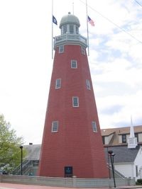 Portland Observatory
 |
Lighthouses
62 lighthouses dot the coast of Maine (we'll get to them all eventually). In Southern Maine, you can visit the Museum at Portland Head Light. This is one of six lighthouses commissioned by George Washington, it was completed in 1791 and operated until 1989 when the light was finally automated.
Admiral Robert E. Peary
Continue on Rt. 1 which extends all the way up the coast, (but bypasses the coastline itself, most of which is in the hands of private property owners.) A controversial figure in the annals of Arctic exploration is Robert Peary, whose claim to be the first to reach the North Pole has been disputed ever since. (Some experts postulate that Peary's assistant (and skilled sled-driver,) the black Matthew Henson, and a group of Inuit guides reached the Pole, while Peary did not.
| Peary-MacMillan Arctic Museum is on the campus of Bowdoin College in Brunswick, the ultimate point of Southern Maine. |
Quiz
1) Name all of Maine's lighthouses, when built and where located.
2) Name all of the towns and cities located off Maine's Rt. 1. (Consult your detailed atlas.)
Send answers to TechnoOcean Academy.
|

NOTE: TechnoOcean Academy is an Academy of the mind. We are not affiliated with any official educational organization.
|
Recommended Reading

Learn more or
Buy Now

Learn more or
Buy Now

Learn more or
Buy Now
|