| I at once conceived the idea of writing a series of travel articles on meteorite craters in America, and decided to start with the Chesapeake Bay crater rim, as I live only about 30 miles from the location he mentions.
I had intended to illustrate this travel article with photos of that scarp, however, as I drove - twice - on the section Poag called out in his book, I have to confess that I saw absolutely nothing worth photographing. There were a couple of places where the land was higher than at other places, but there was nothing 'abrupt' about the elevation, and it wasn't a continuous boundary...there was nothing to make one think: "This is odd. Looks like something hit here."
|
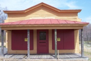
James Store |
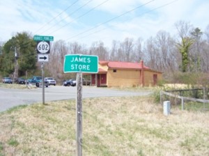
James Store coming from the opposite direction. |
However, I decided to take Burkes Pond Rd (just past James Store on the left as you come from Gloucester, with James Store on your left) and drove on that, and then I did see some sharp elevation changes - going down as I looked at them, rather than up, including a body of water with a short waterfall at one end, but whether these were made by erosion cutting through the ground, man-made, or caused by the impact 35 million years ago, I am unable to say!
James Store, by the way, is not a village, but simply a building, closed down now, although its parking lot is still used. Indeed when I parked there to take these photos I joined about 8 other cars. Where their owners were or what they were doing I don't know. |
I live in York County, just off Highway 17, so it was no hardship to get on the highway and go North towards Gloucester, about 20 miles away. There is a toll road just after the highway crosses over the James River: 75 cents for motorcycles, $2 for cars. However, you do not have to pay a toll to return from the opposite direction.
I had gotten my directions via Mapquest (which did have James Store listed as a viable location - which is why I was surprised when I eventually got there to find out there was no such village. It was simply a building) although once I got into Gloucester the directions failed me and I merely kept driving until I saw the sign for VA-14 East, and turned right onto that road.
At this point I was still looking for a village, with a sign saying James Store, and never saw it. I looked to my left at the stands of trees, etc. and never saw anything dramatic. Finally, after 10 miles, I turned around and returned to Gloucester. I turned into a parking lot of what I thought was a store and what turned out to be a pawn shop. The people there were very friendly (of the three, one had heard of the Chesapeake Bay crater), pointed out that James Store was just a store and that it was painted burnt orange, and that yes, indeed, the land did change elevation, "whoosh," like that.
So I retraced my steps, again looking for that sharp elevation change and never seeing it. I also never noticed the burnt orange building that should have been on my left, until I again turned around and came back and this time saw it, now on my right hand side. I turned right onto Burkes Pond Rd, just to see if there was anything behind it, and as I stated above, that's when I came across those sharp elevation changes - but only in bits of land about 10 feet long - certainly nothing continuous to suggest a boundary. Unfortunately, the road was narrow and the only driveways belonged to private homes, so I was reluctant to pull into one in order to take photographs of these spots.
Travel Verdict
Unless you're very knowledgeable about land formations/geology, I don't think it's worth your while making a special trip to Gloucester to see the Virginia Scarp. However, Gloucester has plenty of more recent history to offer - and there's a location near here where you can see the Ghost Fleet - so if you're going to be in Gloucester anyway, than by all means check out the rim. [According to Poag, it's also possible to see the rim from the Delmarva Peninsula. His directions to see that are below.]
The Chesapeake Bay Crater
| Despite its title, Chesapeake Invader is not a book about non-native species invading Chesapeake Bay, but rather a tale of how the giant meteorite crater on the bottom of Chesapeake Bay was discovered. The title is indeed finished off with Discovering America's Giant Meteorite Crater, but that's not on the spine, so the average space science enthusiast could quite easily miss it. Since I'm interested in both space science and marine science, I would have been happy either way...
Author Poag is a senior research scientist with the U.S. Geological Survey in Woods Hole, Massachusetts. According to the bio in the book: "His research emphasizes the integration of subsurface geophysical, geological and paleontological data to reconstruct the stratigraphic framework and depositional history of the Atlantic and Gulf Coast margins of the United States.
Pag's directions to the rim on the Delmarva peninsula:
"Take U.S. Highway 13 north from Kiptopeke to Painter. A sharp, 15-ft rise in topographic elevation to the west of the road near Painter is called Ames Ridge. The ridge approximates the position of the buried crater rim in this area."
Ames Ridge, Poag continues, "marks the geological boundary between the younger sedimentary formations inside the crater and older sediments outside the crater."
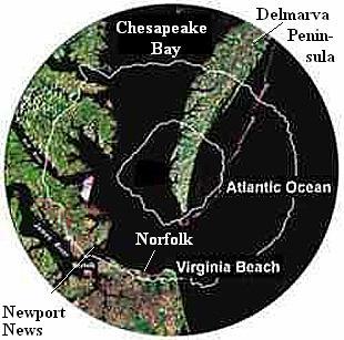
The Chesapeake Bay impact crater is the largest meteorite crater in the United States, for all that most of it is under water.
|
1. Telltales
2. Microfossil Magic
3. Tektites
4. Toms Canyon
5. Super Tsunami
6. Chesapeake Crater Revealed
7. Proof in the Pudding
8. A Perilous Path
9. Mass Extinctions
10. Eocene Environments
11. Sinking Sand
12. Threatened Ground Waters
13. Faulty Floor
14. Seaward Explorer
15. Buried Treasure
16. Subterranean Waste
17. Chicken Little's Dilemma
Glossary
Suggestions for Further Reading
Recommended WWW sites
Index |
| The Chesapeake Crater and Virginian Groundwater
According to Poag, the quality of ground-water in southeastern Virginia had long puzzled geohydrologists. Why did so many shallow water wells, especially on the western side of Chesapeake Bay, produce unusually salty water - in some cases even brine?
Water-quality tests show the that the brine saturates the porous Exmore breccia (fill inside a crater) but is absent from shallower acquifers lying above the breccia. The brine is sealed off from younger freshwater reservoirs by the Chickahominy formation, a 300-ft thick confining unit of impervious clay, which overlies the breccia.
This brine poses a potential environmental hazard for the lower Chesapeake Bay region. If the brine should seep upward for any reason (from natural causes to improper drilling by humans), it would defile the freshwater aquifers above - forever.
|
 |
Three quotes from Poag:
| Scientific understanding continually evolves, much like a lineage of living organisms. We discard outdated hypotheses and propose new ones as we incorporate fresh insights and concepts to answer questions about our natural environment. |
| Learning what others have previously written on a subject is a necessary part of problem solving for a scientist, particularly in a historical science like geology. |
| Misinterpretations and rejected hypotheses routinely contribute to the advancement of scientific understanding. |
|